

The Carter Range (Carter Dome, Middle Carter, South Carter)
- Eliza Laycock
- Jun 9, 2021
- 4 min read
Date: 5/29/2021
Carter Dome Elevation: 4,832’
South Carter Elevation: 4,430’
Middle Carter Elevation: 4,610’
Miles: somewhere around 14 miles
Time: 8 hours, 38 minutes
Trails: Nineteen Mile Brook Trail to Carter Dome Trail to Carter-Moriah Trail to North Carter Trail to Imp Trail
So in my last blog post I talked about how I wanted to start with some easier hikes this summer to get my hiking legs back under me…well I messed that up choosing the Tripyramids and then did again right after with the Carters. But I mean I guess one way to get your hiking legs back is to just hike for an entire day and gain nearly 5,000 feet of elevation??
It was Memorial Day weekend so the Carters seemed like a safe bet to avoid the crowds that people in the 4000 footer Facebook group were warning everyone about—they’re a range that’s pretty far north in Gorham and don’t offer super spectacular views aside from Mount Hight (I personally beg to differ but some people are very particular about their views). The forecast was also predicting very cold temps and a lot of wind chill, so that may have helped the crowds too.
But because of the forecast and the horror stories I’ve heard of ill-prepared hikers in the Whites, I packed my backpack practically like it was a full-on winter hike. I even decided to break in my winter hiking boots. I’ll be honest, I COMPLETELY overpacked, but better to be safe (like super extra overly safe with multiple jackets, pants, and winter gloves) than sorry??
Mary and I met up at the Nineteen Mile Brook trailhead just after 8am and I strapped on my giant 32 liter pack that, with its green color, really made me look like a turtle. Even though it was only 50º, once we got moving I quickly stripped off my extra layers that I had overcautiously put on.

Not too much to note on the Nineteen Mile Brook trail, but the stream is really beautiful and the trail isn’t too difficult. We eventually got to Zeta Pass and peeled right to ascend up one more mile to Carter Dome, which we reached about three hours after the start of our hike. Although Carter Dome is the tallest peak in the Carter Range, there’s not many views to speak of—especially since it was really foggy.
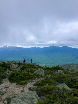
Coming back to the main trail from Carter Dome, you have two choices: either go back the way you came (1 mile) or cut to the right and hit Mount Hight (1.3 miles). While Mt. Hight isn’t a 4000 footer, I had read that it has the best views of the hike; we debated skipping the extra 0.3 with the fog and low visibility, but decided to hit Hight anyways in case there were still some views. Though the clouds hung low, Hight did not disappoint. It’s beautiful up there and while we didn’t stick around that long because of the cold, I definitely would recommend that anyone add the extra 0.3 to tag Hight.


Once back to the Carter-Moriah trail, it’s just over the ridge to South Carter (also limited views) and then Middle Carter. There is a good amount of up-and-down here, which is how we got so much elevation gain, but there are some really nice lookout points along the way too. The trees had these beautiful ice crystals on one side of the branches—it’s cool how each hike has something new in nature to offer :)

Starting around Carter Dome we had begun leapfrogging with this pair of really kind men (oxymoron much?!) who even offered us some of their fruit snacks. We hiked with them on-and-off and would see them on the peaks as well. We came off Middle Carter with them and had another choice to make, either just go down from there or hike a littleee bit more to tag our fifth peak of the day, North Carter. I was pretty gassed at this point and North Carter isn’t a 4000 footer so I was kind of out on it, but the men convinced Mary and I to make the last push up to hit it. It ended up being worth it with beautiful views since the fog had burned off by now. By now it was around 2:30 and our legs were ready for some downhill hiking.

The men had told us about a bushwhack on the Imp Trail that would lead us back to our cars and help us avoid walking on the highway, but we only had a very vague idea of where it was. We kept our eyes peeled for the bushwhack but never ended up finding it…We did find a trail that spit us out at Camp Dodge, which is a site that provides housing and logistic support to AMC volunteers and staff. It’s a pretty cute area and they let us use their bathrooms so extra points for that.
I don’t think the Camp Dodge trail was the bushwhack we were looking for, but it did cut our distance walking on the road way down. We came out on Route 16 and had about a 10 minute walk back up to our cars. At this point I was feeling pretty delusional from hiking for so long and crushing so much elevation. What a LONG day, but we hit 5 peaks so props to us. I felt like I was recovering from this hike for at least five days afterwards, but it’s one hike closer to my hiking legs.


Comments